Health nearby Ás sjúkraþjálfun
Coronavirus disease (COVID-19) Situation
confirmed cases
209906
deaths
229
Iceland
Health nearby Ás sjúkraþjálfun
Ás sjúkraþjálfun
115, Hraunbær, Reykjavík, IS Ísland
contacts phone
:
+354 577 5575
website:
www.assjukra.is
Latitude:
64.1186056
, Longitude:
-21.799702
larger map & directions
read more
nearest Health
166 m
Naturalne Piękno
Hraunbær 102, Reykjavík
Health
read more
452 m
Hugmeðferð
Reykjavík
Health
read more
597 m
Sálfræðingarnir Lynghálsi
9, 110, Lyngháls, Reykjavík
Health
read more
741 m
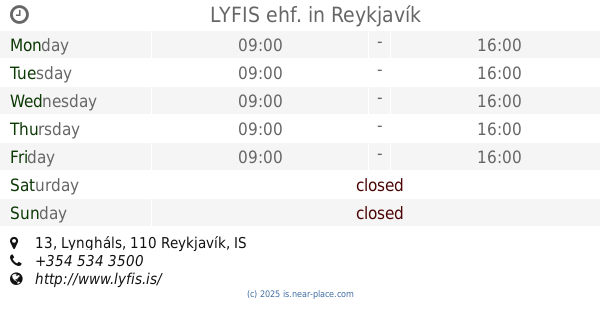
LYFIS ehf.
Lyngháls 13, Reykjavík
Health
read more
864 m
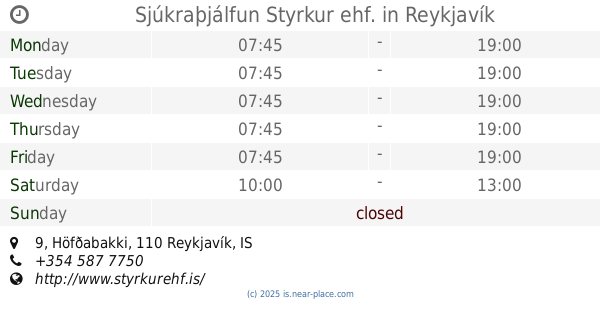
Sjúkraþjálfun Styrkur ehf.
Höfðabakki 9, Reykjavík
Health
read more
941 m
Líf og Sál - Sálfræðistofa
Höfðabakki 9, Reykjavík
Health
read more
1.34 km
Heilsugæslan Höfða
Bíldshöfði 9, Reykjavík
Health
read more
1.674 km
Heilsugæslan Efra Breiðholti
Hraunberg 5, Reykjavík
Health
read more
1.787 km
Íþróttamiðstöðin Austurbergi
Austurberg 3, Reykjavík
Health
read more
2.095 km
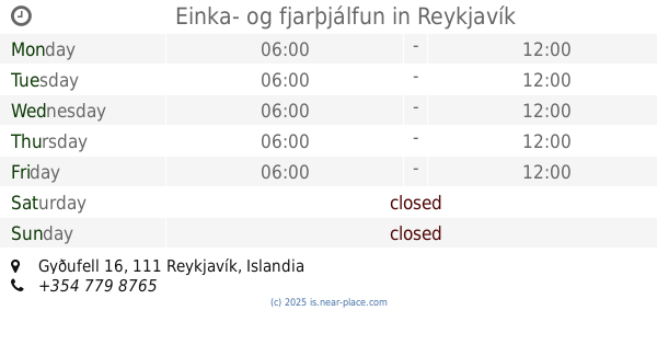
Einka- og fjarþjálfun
Gyðufell 16, Reykjavík
Health
read more
2.358 km
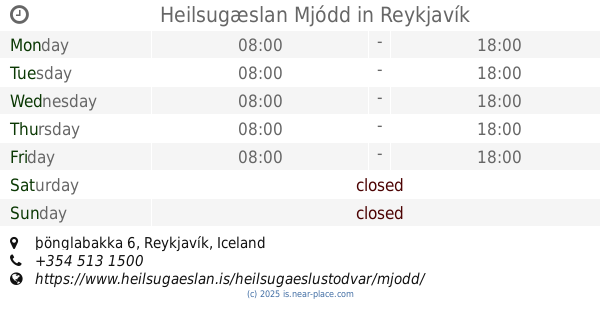
Heilsugæslan Mjódd
þönglabakka 6, Reykjavík
Health
read more
2.36 km
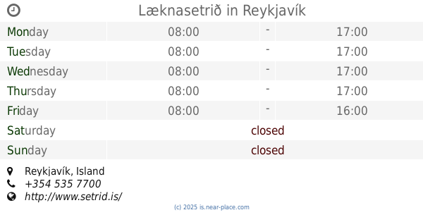
Læknasetrið
Reykjavík
Health
read more
2.444 km
Heilsuvernd
Urðarhvarf 14, Kópavogur
Health
read more
2.458 km
EIR HJÚKRUNARHEIMILI
Hlídarhús 7,, Reykjavík
Health
read more
2.531 km
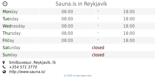
Sauna.is
11,, Smiðjuvegur, Reykjavík
Health
read more
2.584 km
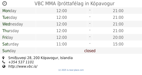
VBC MMA íþróttafélag
Smiðjuvegi 28, Kópavogur
Health
read more
2.625 km
Intermedica
Skemmuvegur 6, Kópavogur
Health
read more
2.745 km
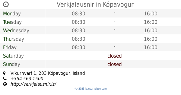
Verkjalausnir
Víkurhvarf 1, Kópavogur
Health
read more
2.746 km
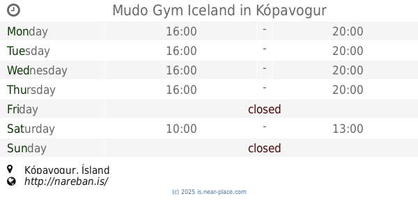
Mudo Gym Iceland
Kópavogur
Health
read more
2.807 km
Bjarkahlíð
Health
read more
3.163 km
Seljahlíð
Hjallasel 55, Reykjavík
Health
read more
3.272 km
Sambýlið Sólheimum 21b
Sólheimar 21a, Reykjavík
Health
read more
3.319 km
Heyrnarhjálp
Langholtsvegur 111, Reykjavík
Health
read more
3.897 km
Ljósið
Langholtsvegur 43, Reykjavík
Health
read more
4.112 km
Karl Guðmundsson Sjálfstæður dreifingaraðili Herbalife
Hjallavegur, Reykjavík
Health
read more
📑
all categories
Accounting
Administrative area level 1
Administrative area level 2
Airport
Amusement park
Aquarium
Art gallery
Atm
Bakery
Bank
Bar
Beauty salon
Bicycle store
Book store
Bowling alley
Bus station
Cafe
Campground
Car dealer
Car rental
Car repair
Car wash
Casino
Cemetery
Church
City hall
Clothing store
Convenience store
Country
Courthouse
Dentist
Department store
Doctor
Electrician
Electronics store
Embassy
Establishment
Finance
Fire station
Florist
Food
Funeral home
Furniture store
Gas station
General contractor
Grocery or supermarket
Gym
Hair care
Hardware store
Health
Hindu Temple
Home goods store
Hospital
Insurance agency
Jewelry store
Laundry
Lawyer
Library
Liquor store
Local government office
Locality
Locksmith
Lodging
Meal delivery
Meal takeaway
Mosque
Movie theater
Moving company
Museum
Natural feature
Neighborhood
Night club
Painter
Park
Parking
Pet store
Pharmacy
Physiotherapist
Place of worship
Plumber
Point of interest
Police
Post office
Premise
Real estate agency
Restaurant
Route
Rv park, camping
School
Shoe store
Shopping mall
Spa
Stadium
Storage
Store
Subpremise
Supermarket
Synagogue
Taxi stand
Transit station
Travel agency
University
Veterinary care
Zoo
sublocality level 1
↑