Point of interest nearby Varðan á Langamel
Iceland
Point of interest nearby Varðan á Langamel
Varðan á Langamel
Islandia
contacts phone
:
+354
Latitude:
65.641509
, Longitude:
-17.343936
larger map & directions
read more
nearest Point of interest
1.43 km
Fellshlíð II
Road Number 847
Point of interest
read more
1.667 km
Víðar
Víðum
Point of interest
read more
1.79 km
Stafn
Road number 847
Point of interest
read more
3.084 km
Brún
Þjóðvegur
Point of interest
read more
5.608 km
Lyngbrekka
Lyngbrekku, Þjóðvegur
Point of interest
read more
6.384 km
Daðastaðir
Þjóðvegur
Point of interest
read more
7.253 km
China-Iceland Joint Aurora Observatory (CIAO)
Þjóðvegur
Point of interest
read more
8.289 km
Arndísarstaðir
Point of interest
read more
8.534 km
Lyngholt
Point of interest
read more
8.818 km
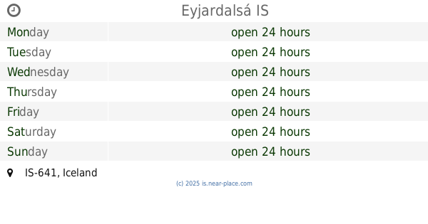
Eyjardalsá
Point of interest
read more
8.914 km
Laugar Sports Center
Austurhlidarvegur, Laugar
Point of interest
read more
8.914 km
Íþróttahúsið á Laugum
Austurhlidarvegur, Laugar
Point of interest
read more
8.915 km
Laugar Swimming Pool
Nebraska 2 650, Grand Island
Point of interest
read more
8.915 km
Sundlaug Laugum
Nebraska 2 650, Grand Island
Point of interest
read more
9.279 km
Hvarf
Iceland
Point of interest
read more
10.295 km
Halldórsstaðir Laxárdal
Iceland
Point of interest
read more
10.505 km
Goðafoss
Nebraska 2 640, Grand Island
Point of interest
read more
10.947 km
Láfsgerði
Þjóðvegur
Point of interest
read more
11.049 km
Öxará
Point of interest
read more
12.754 km
Vindbelgjarfjall
Iceland
Point of interest
read more
13.126 km
Ljósavatn
Ljósavatnsvegur
Point of interest
read more
14.731 km
Lake Mývatn View Point
Þjóðvegur, Reykjahlidh
Point of interest
read more
15.474 km
Lake Myvatn
Lake Myvatn
Point of interest
read more
16.226 km
Skútustaðagígar
Iceland
Point of interest
read more
16.335 km
Ljósavatn Mirrow Lake
Ljosavatn
Point of interest
read more
📑
all categories
Accounting
Administrative area level 1
Administrative area level 2
Airport
Amusement park
Aquarium
Art gallery
Atm
Bakery
Bank
Bar
Beauty salon
Bicycle store
Book store
Bowling alley
Bus station
Cafe
Campground
Car dealer
Car rental
Car repair
Car wash
Casino
Cemetery
Church
City hall
Clothing store
Convenience store
Country
Courthouse
Dentist
Department store
Doctor
Electrician
Electronics store
Embassy
Establishment
Finance
Fire station
Florist
Food
Funeral home
Furniture store
Gas station
General contractor
Grocery or supermarket
Gym
Hair care
Hardware store
Health
Hindu Temple
Home goods store
Hospital
Insurance agency
Jewelry store
Laundry
Lawyer
Library
Liquor store
Local government office
Locality
Locksmith
Lodging
Meal delivery
Meal takeaway
Mosque
Movie theater
Moving company
Museum
Natural feature
Neighborhood
Night club
Painter
Park
Parking
Pet store
Pharmacy
Physiotherapist
Place of worship
Plumber
Point of interest
Police
Post office
Premise
Real estate agency
Restaurant
Route
Rv park, camping
School
Shoe store
Shopping mall
Spa
Stadium
Storage
Store
Subpremise
Supermarket
Synagogue
Taxi stand
Transit station
Travel agency
University
Veterinary care
Zoo
sublocality level 1
↑