Lodging nearby Vestri Grund 1
Iceland
Lodging nearby Vestri Grund 1
Vestri Grund 1
Iceland
contacts phone
:
+354 483 1451
Latitude:
63.8306769
, Longitude:
-21.0211372
larger map & directions
read more
nearest Lodging
51 m
Bjarmaland
Stokkseyri
Lodging
read more
1.776 km
Húsið við Hafið
Íragerði 14, Stokkseyri
Lodging
read more
1.822 km
Guesthouse Heba
Íragerði 12, Stokkseyri
Lodging
read more
1.87 km
Freyja bed & breakfast
Blómsturvellir, Stokkseyri
Lodging
read more
2.202 km
Art Hostel
Hafnargata 9, Stokkseyri
Lodging
read more
7.23 km
巴齊旅館公寓
862756, -21.149461, Bíldudalsvegur
Lodging
read more
7.412 km
Merkigil
Eyrargata Merkigil, Eyrarbakki
Lodging
read more
7.673 km
Guesthouse Tindástoll
Búðarstígur, Eyrarbakki
Lodging
read more
9.92 km
Brimhouse
Brimstaðir Floahreppi, Gaulverjabaer
Lodging
read more
11.117 km
9 Álftarimi
9, Álftarimi, Selfoss
Lodging
read more
11.36 km
Downtown Selfoss - perfectly located apartment
34, Sigtún, Selfoss
Lodging
read more
11.406 km
Vík Apartments
Sléttuvegur 4, Vík
Lodging
read more
11.425 km
Hreidurborg
Iceland
Lodging
read more
11.634 km
Guesthouse 14
Birkivellir 14, Selfoss
Lodging
read more
11.904 km
Au44 hostel
Austurvegur 44, Selfoss
Lodging
read more
11.906 km
Thoristun apartment
800, Þóristún, Selfoss
Lodging
read more
12.227 km
River Apartments
Jórutún 6, Selfoss
Lodging
read more
12.725 km
Hotel Vatnsholt
Vatnsholt 2, South
Lodging
read more
12.761 km
Vatnsholt - Guest House
Vatnsholti 2, Villingaholt
Lodging
read more
12.908 km
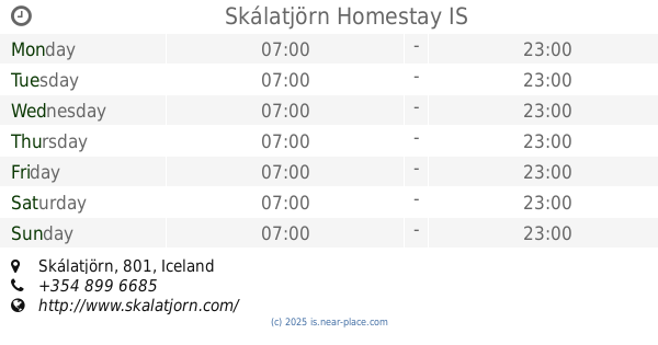
Skálatjörn Homestay
Skálatjörn
Lodging
read more
14.119 km
Elding Apartments
Hvoll 1
Lodging
read more
14.343 km
Silfurberg Guesthouse
Iceland
Lodging
read more
14.864 km
Stekkholt 3
Stekkholtsvegur
Lodging
read more
18.363 km
Hotel Hlid
Sveitarfélagið Ölfus
Lodging
read more
18.486 km
360 degree Hotel and Lodge
Hnaus 2, Ring Road No. 1, Selfoss
Lodging
read more
📑
all categories
Accounting
Administrative area level 1
Administrative area level 2
Airport
Amusement park
Aquarium
Art gallery
Atm
Bakery
Bank
Bar
Beauty salon
Bicycle store
Book store
Bowling alley
Bus station
Cafe
Campground
Car dealer
Car rental
Car repair
Car wash
Casino
Cemetery
Church
City hall
Clothing store
Convenience store
Country
Courthouse
Dentist
Department store
Doctor
Electrician
Electronics store
Embassy
Establishment
Finance
Fire station
Florist
Food
Funeral home
Furniture store
Gas station
General contractor
Grocery or supermarket
Gym
Hair care
Hardware store
Health
Hindu Temple
Home goods store
Hospital
Insurance agency
Jewelry store
Laundry
Lawyer
Library
Liquor store
Local government office
Locality
Locksmith
Lodging
Meal delivery
Meal takeaway
Mosque
Movie theater
Moving company
Museum
Natural feature
Neighborhood
Night club
Painter
Park
Parking
Pet store
Pharmacy
Physiotherapist
Place of worship
Plumber
Point of interest
Police
Post office
Premise
Real estate agency
Restaurant
Route
Rv park, camping
School
Shoe store
Shopping mall
Spa
Stadium
Storage
Store
Subpremise
Supermarket
Synagogue
Taxi stand
Transit station
Travel agency
University
Veterinary care
Zoo
sublocality level 1
↑