Restaurant nearby Cafe Catalína
Iceland
Restaurant nearby Cafe Catalína
Cafe Catalína
11, Hamraborg, 200, Kópavogur, IS Iceland
contacts phone
:
+354 554 2166
Latitude:
64.1126963
, Longitude:
-21.9022805
larger map & directions
read more
nearest Restaurant
17 m
Subway
Hamraborg 11, Kópavogur
Restaurant
read more
101 m
Jordan Grill
Kópavogur
Restaurant
read more
102 m
Ali Baba
Hamraborg 14 a, Kópavogur
Restaurant
read more
289 m
Fylgifiskar
Nýbýlavegur 4, Kópavogur
Restaurant
read more
298 m
Tokyo sushi
Nýbýlavegur 4, Kópavogur
Restaurant
read more
319 m
Nam
Nýbýlavegur 6, Kópavogur
Restaurant
read more
326 m
Serrano
Nýbýlavegur 6-8, Kópavogur
Restaurant
read more
374 m
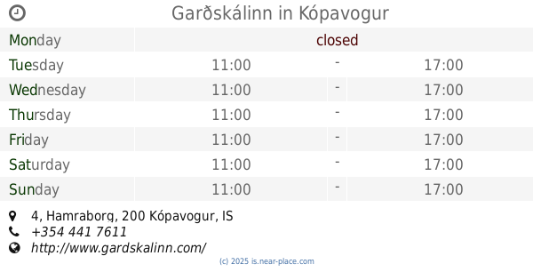
Garðskálinn
Hamraborg 4, Kópavogur
Restaurant
read more
478 m
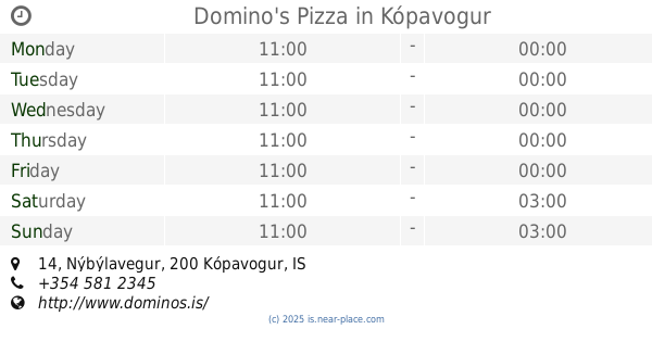
Domino's Pizza
Nýbýlavegur 14, Kópavogur
Restaurant
read more
530 m
Kínahofið - Veitingahús
Nýbýlavegur 20, Kópavogur
Restaurant
read more
553 m
American Style, Nýbýlavegi
Nýbýlavegur 22, Kópavogur
Restaurant
read more
566 m
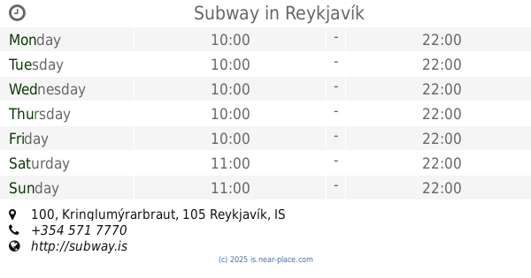
Subway
Kringlumýrarbraut 100, Reykjavík
Restaurant
read more
1.459 km
XO
Norðurturni við Smáralind, 3 201, Hagasmári, Kópavogur
Restaurant
read more
1.519 km
Food Station
Kópavogur
Restaurant
read more
1.556 km
Castello Pizzeria
Dalvegur 2, Kópavogur
Restaurant
read more
1.581 km
Wok On
Smárinn, Kópavogur
Restaurant
read more
1.67 km
Pizza Hut
1, Hagasmári, Kópavogur
Restaurant
read more
1.733 km
Café Atlanta
Smarinn, Kópavogur
Restaurant
read more
1.808 km
KFC
Bæjarlind 18, Kópavogur
Restaurant
read more
1.811 km
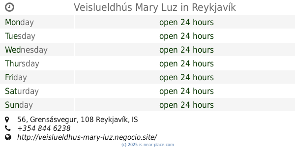
Veislueldhús Mary Luz
Grensásvegur 56, Reykjavík
Restaurant
read more
1.83 km
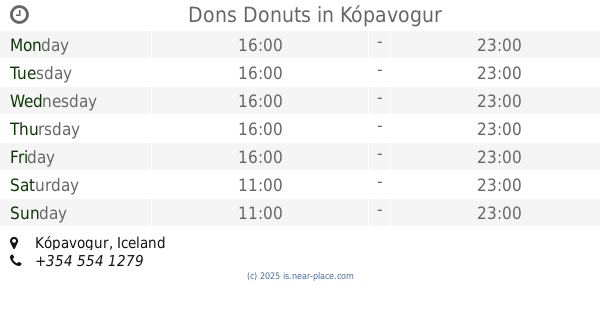
Dons Donuts
Kópavogur
Restaurant
read more
1.909 km
Serrano - Kringlan
Kringlunni 4-12, Reykjavík
Restaurant
read more
1.92 km
Hamborgarafabrikkan
103, Kringlan 4, Reykjavík
Restaurant
read more
2.555 km
Hlöllabátar
Faxafen, Reykjavík
Restaurant
read more
2.629 km
Erlu Ís
Fákafen 52, Reykjavík
Restaurant
read more
📑
all categories
Accounting
Administrative area level 1
Administrative area level 2
Airport
Amusement park
Aquarium
Art gallery
Atm
Bakery
Bank
Bar
Beauty salon
Bicycle store
Book store
Bowling alley
Bus station
Cafe
Campground
Car dealer
Car rental
Car repair
Car wash
Casino
Cemetery
Church
City hall
Clothing store
Convenience store
Country
Courthouse
Dentist
Department store
Doctor
Electrician
Electronics store
Embassy
Establishment
Finance
Fire station
Florist
Food
Funeral home
Furniture store
Gas station
General contractor
Grocery or supermarket
Gym
Hair care
Hardware store
Health
Hindu Temple
Home goods store
Hospital
Insurance agency
Jewelry store
Laundry
Lawyer
Library
Liquor store
Local government office
Locality
Locksmith
Lodging
Meal delivery
Meal takeaway
Mosque
Movie theater
Moving company
Museum
Natural feature
Neighborhood
Night club
Painter
Park
Parking
Pet store
Pharmacy
Physiotherapist
Place of worship
Plumber
Point of interest
Police
Post office
Premise
Real estate agency
Restaurant
Route
Rv park, camping
School
Shoe store
Shopping mall
Spa
Stadium
Storage
Store
Subpremise
Supermarket
Synagogue
Taxi stand
Transit station
Travel agency
University
Veterinary care
Zoo
sublocality level 1
↑