Restaurant nearby Kaffi kið
Iceland
Restaurant nearby Kaffi kið
Kaffi kið
Golfklúbbur Kiðjabergs, 801 Selfoss, Ísland
contacts phone
:
+354 699 4969
website:
www.facebook.com
Latitude:
64.001116
, Longitude:
-20.778781
larger map & directions
read more
nearest Restaurant
8.787 km
Minniborgir Restaurant
Iceland
Restaurant
read more
8.787 km
Restaurant Minniborgir
Iceland
Restaurant
read more
8.832 km
Restaurant Minniborgir
Minni-Borg, Selfoss
Restaurant
read more
9.516 km
Þrastalundur
Iceland
Restaurant
read more
11.392 km
Matur & Músík
Iceland
Restaurant
read more
11.69 km
Krían Sveitakrá
Kríumýri
Restaurant
read more
12.391 km
Hlölla Bátar
Austurvegur 9, Selfoss
Restaurant
read more
12.475 km
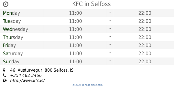
KFC
Austurvegur 46, Selfoss
Restaurant
read more
12.48 km
Skalli
Austurvegur 46, Selfoss
Restaurant
read more
12.755 km
Surf and Turf
Austurvegur 22, Selfoss
Restaurant
read more
12.762 km
Surf & Turf Steakhouse
Austurvegur 22, Selfoss
Restaurant
read more
12.921 km
Vefjan
Tryggvagata 8, Selfoss
Restaurant
read more
12.923 km
Kaffi Krús
Austurvegur 7, Selfoss
Restaurant
read more
12.993 km
Yellow
Selfoss
Restaurant
read more
13.026 km
Tryggvaskáli
Tryggvatorg, Selfoss
Restaurant
read more
13.064 km
Pylsuvagninn
Árvegur, Selfoss
Restaurant
read more
13.108 km
Subway
Selfoss
Restaurant
read more
13.141 km
Noodle Station Selfoss
Eyravegur 3, Selfoss
Restaurant
read more
13.478 km
Seylon
Tryggvagata 16, Selfoss
Restaurant
read more
13.529 km
Tommi's Burger Joint
32, Eyravegur, Selfoss
Restaurant
read more
13.544 km
Vatnsholt Guesthouse
Árnessýslu
Restaurant
read more
19.74 km
Restaurant Varma
Hveragerði
Restaurant
read more
19.788 km
Skyrgerðin Café & Bistro
Breiðamörk 25 - 810, Hveragerði
Restaurant
read more
23.043 km
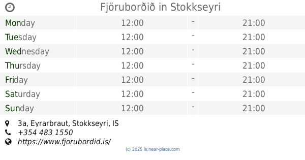
Fjöruborðið
Eyrarbraut 3a, Stokkseyri
Restaurant
read more
25.686 km
Hafið Bláa
Óseyrartanga við ósa Ölfusár, Thorlakshofn
Restaurant
read more
📑
all categories
Accounting
Administrative area level 1
Administrative area level 2
Airport
Amusement park
Aquarium
Art gallery
Atm
Bakery
Bank
Bar
Beauty salon
Bicycle store
Book store
Bowling alley
Bus station
Cafe
Campground
Car dealer
Car rental
Car repair
Car wash
Casino
Cemetery
Church
City hall
Clothing store
Convenience store
Country
Courthouse
Dentist
Department store
Doctor
Electrician
Electronics store
Embassy
Establishment
Finance
Fire station
Florist
Food
Funeral home
Furniture store
Gas station
General contractor
Grocery or supermarket
Gym
Hair care
Hardware store
Health
Hindu Temple
Home goods store
Hospital
Insurance agency
Jewelry store
Laundry
Lawyer
Library
Liquor store
Local government office
Locality
Locksmith
Lodging
Meal delivery
Meal takeaway
Mosque
Movie theater
Moving company
Museum
Natural feature
Neighborhood
Night club
Painter
Park
Parking
Pet store
Pharmacy
Physiotherapist
Place of worship
Plumber
Point of interest
Police
Post office
Premise
Real estate agency
Restaurant
Route
Rv park, camping
School
Shoe store
Shopping mall
Spa
Stadium
Storage
Store
Subpremise
Supermarket
Synagogue
Taxi stand
Transit station
Travel agency
University
Veterinary care
Zoo
sublocality level 1
↑