Restaurant nearby KFC
Iceland
Restaurant nearby KFC
KFC
Háholt, 270, Mosfellsbær, IS Islandia
contacts phone
:
+354 515 0920
website:
www.kfc.is
Latitude:
64.1665475
, Longitude:
-21.6938881
larger map & directions
read more
nearest Restaurant
90 m
Subway
Mosfellsbær
Restaurant
read more
150 m
Boost Burger And Ice
Mosfellsbær
Restaurant
read more
1.924 km
BLIK Bistro&Grill
Æðarhöfði 36, Mosfellsbær
Restaurant
read more
1.975 km
BLIK Bistro&Grill
Mosfellsbær
Restaurant
read more
2.182 km
Blikk Bistro&Grill
Mosfellsbær
Restaurant
read more
4.137 km
Grillið Hjá Möggu
Reykjavík
Restaurant
read more
4.404 km
Shake & Pizza
1,, Fossaleynir, Reykjavík
Restaurant
read more
4.813 km
Serrano
Reykjavík
Restaurant
read more
4.849 km
Esjustofa - veitinga og þjónustumiðstöð
Mógilsá
Restaurant
read more
4.907 km
Subway
Spöngin 19a, Reykjavík
Restaurant
read more
4.913 km
Domino's Pizza
Spöngin, Reykjavík
Restaurant
read more
4.928 km
Gríska Húsið
Móavegur, Reykjavík
Restaurant
read more
4.936 km
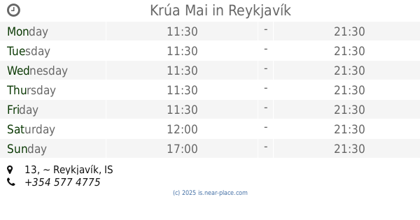
Krúa Mai
13, Reykjavík
Restaurant
read more
4.937 km
Ali Baba
Móavegur, Reykjavík
Restaurant
read more
5.113 km
KFC
113, Þjóðhildarstígur 1, Reykjavík
Restaurant
read more
5.362 km
Rima Grill
21 ~, Langirimi, Reykjavík
Restaurant
read more
9.321 km
Hlöllabátar
Faxafen, Reykjavík
Restaurant
read more
10.078 km
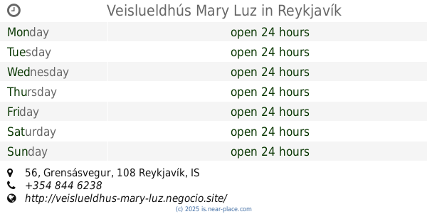
Veislueldhús Mary Luz
Grensásvegur 56, Reykjavík
Restaurant
read more
11.121 km
Sala Grill
Rjúpnasalir, Kópavogur
Restaurant
read more
11.478 km
Meze
42,, Laugavegur 32, Reykjavík
Restaurant
read more
11.791 km
Ostabúðin
Skólavörðustígur 8, Reykjavík
Restaurant
read more
11.858 km
Tommi's Burger Joint
Bankastræti 3, Reykjavík
Restaurant
read more
11.877 km
BÚLLAN BURGER JOINT
Bankastræti 5, Reykjavík
Restaurant
read more
12.222 km
Ramen Momo
Tryggvagata 16, Reykjavík
Restaurant
read more
15.507 km
Noodle Station
4,, Bæjarhraun Bæjarhraun 16, 220, Hafnarfjordur
Restaurant
read more
📑
all categories
Accounting
Administrative area level 1
Administrative area level 2
Airport
Amusement park
Aquarium
Art gallery
Atm
Bakery
Bank
Bar
Beauty salon
Bicycle store
Book store
Bowling alley
Bus station
Cafe
Campground
Car dealer
Car rental
Car repair
Car wash
Casino
Cemetery
Church
City hall
Clothing store
Convenience store
Country
Courthouse
Dentist
Department store
Doctor
Electrician
Electronics store
Embassy
Establishment
Finance
Fire station
Florist
Food
Funeral home
Furniture store
Gas station
General contractor
Grocery or supermarket
Gym
Hair care
Hardware store
Health
Hindu Temple
Home goods store
Hospital
Insurance agency
Jewelry store
Laundry
Lawyer
Library
Liquor store
Local government office
Locality
Locksmith
Lodging
Meal delivery
Meal takeaway
Mosque
Movie theater
Moving company
Museum
Natural feature
Neighborhood
Night club
Painter
Park
Parking
Pet store
Pharmacy
Physiotherapist
Place of worship
Plumber
Point of interest
Police
Post office
Premise
Real estate agency
Restaurant
Route
Rv park, camping
School
Shoe store
Shopping mall
Spa
Stadium
Storage
Store
Subpremise
Supermarket
Synagogue
Taxi stand
Transit station
Travel agency
University
Veterinary care
Zoo
sublocality level 1
↑