Bar nearby Austur
Coronavirus disease (COVID-19) Situation
confirmed cases
209906
deaths
229
Iceland
Bar nearby Austur
Austur
8, Hafnarstræti, 101, Reykjavík, IS Islandia
contacts phone
:
+354 568 1907
website:
www.austurbar.is
Latitude:
64.1479063
, Longitude:
-21.9397234
larger map & directions
read more
nearest Bar
29 m
The Drunk rabbit Irish Pub
Austurstræti 3, Reykjavík
Bar
read more
38 m
The English Pub
Austurstræti 12, Reykjavík
Bar
read more
49 m
Pablo Discobar
Veltusund 1, Reykjavík
Bar
read more
79 m
The Dubliner
Hafnarstræti 1-3, 101, Naustin, Reykjavík
Bar
read more
86 m
Paloma bar
1-3,, Naustin, Reykjavík
Bar
read more
88 m
Húrra
Downtown, Reykjavík
Bar
read more
92 m
Bjarni Fel Sportbar
Austurstræti 20, Reykjavík
Bar
read more
93 m
Gaukurinn
Tryggvagata 22, Reykjavík
Bar
read more
112 m
Hotel Borg by Keahotels
Pósthússtræti 11, Reykjavík
Bar
read more
120 m
Grillhúsið
Tryggvagata, Reykjavík
Bar
read more
194 m
Ölsmiðjan Bar/Cafe
Lækjargata, Reykjavík
Bar
read more
276 m
B5
Bankastræti 5, Reykjavík
Bar
read more
334 m
Den Danske Kro ( Danska Kráin )
Ingólfsstræti 3, Reykjavík
Bar
read more
461 m
Le Bistro
Laugavegur 12, Reykjavík
Bar
read more
551 m
Lebowski Bar
Laugavegur 20b, Reykjavík
Bar
read more
560 m
Veðurbarinn / Veður Bar & Café
Klapparstígur 33, Reykjavík
Bar
read more
575 m
The Irishman Pub
Klapparstígur 27, Reykjavík
Bar
read more
576 m
Vedur
Klapparstígur 33, Reykjavík
Bar
read more
640 m
Port9
Veghúsarstígur 9, Reykjavík
Bar
read more
765 m
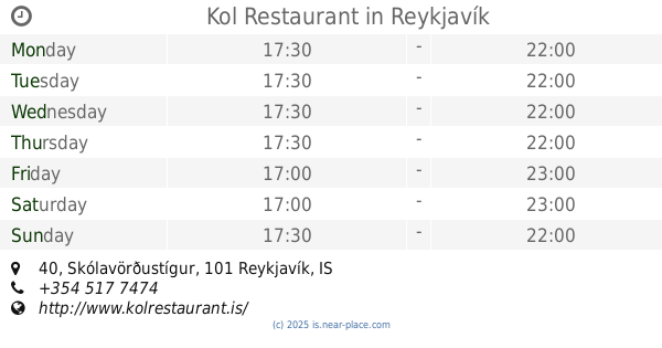
Kol Restaurant
Skólavörðustígur 40, Reykjavík
Bar
read more
778 m
BrewDog Reykjavik
Frakkastígur 8, Reykjavík
Bar
read more
797 m
Bar 7, Bar, Café, Museum
Reykjavík
Bar
read more
909 m
Artson Cocktail Bar
Laugavegur 59 2nd floor, Reykjavík
Bar
read more
953 m
Place in Iceland... Alfreds
Reykjavík
Bar
read more
1.02 km
Mímisbar & Lounge
Hagatorg, Reykjavík
Bar
read more
📑
all categories
Accounting
Administrative area level 1
Administrative area level 2
Airport
Amusement park
Aquarium
Art gallery
Atm
Bakery
Bank
Bar
Beauty salon
Bicycle store
Book store
Bowling alley
Bus station
Cafe
Campground
Car dealer
Car rental
Car repair
Car wash
Casino
Cemetery
Church
City hall
Clothing store
Convenience store
Country
Courthouse
Dentist
Department store
Doctor
Electrician
Electronics store
Embassy
Establishment
Finance
Fire station
Florist
Food
Funeral home
Furniture store
Gas station
General contractor
Grocery or supermarket
Gym
Hair care
Hardware store
Health
Hindu Temple
Home goods store
Hospital
Insurance agency
Jewelry store
Laundry
Lawyer
Library
Liquor store
Local government office
Locality
Locksmith
Lodging
Meal delivery
Meal takeaway
Mosque
Movie theater
Moving company
Museum
Natural feature
Neighborhood
Night club
Painter
Park
Parking
Pet store
Pharmacy
Physiotherapist
Place of worship
Plumber
Point of interest
Police
Post office
Premise
Real estate agency
Restaurant
Route
Rv park, camping
School
Shoe store
Shopping mall
Spa
Stadium
Storage
Store
Subpremise
Supermarket
Synagogue
Taxi stand
Transit station
Travel agency
University
Veterinary care
Zoo
sublocality level 1
↑