Point of interest nearby Akranes
Iceland
Point of interest nearby Akranes
Akranes
Einigrund, Akranes, IS Islandia
contacts phone
:
+354
Latitude:
64.320511
, Longitude:
-22.058235
larger map & directions
read more
nearest Point of interest
221 m
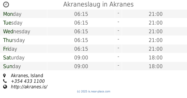
Akraneslaug
Akranes
Point of interest
read more
394 m
Akrasel
Ketilsflöt 2, Akranes
Point of interest
read more
414 m
Brautin Car Rental
Dalbraut, Akranes
Point of interest
read more
428 m
StayWest
Esjubraut 49, Akranes
Point of interest
read more
429 m
Ritari ehf
Esjubraut 49, Akranesi
Point of interest
read more
429 m
VS Tölvuþjónusta
Akranes
Point of interest
read more
450 m
Topp Spjall
Smiðjuvellir, Akranes
Point of interest
read more
464 m
Tölvuverkstæði DJ Danna
Smiðjuvellir 14, Smiðjuvellir, Akranes
Point of interest
read more
464 m
Skaga Rásin
Smiðjuvellir 14, Akranes
Point of interest
read more
507 m
Langisandur
Akranes
Point of interest
read more
511 m
Endurskoðunarstofan Álit
Akranes
Point of interest
read more
513 m
Police
Þjóðbraut, Akranes
Point of interest
read more
633 m
Model
Stekkjarholt 6, Akranes
Point of interest
read more
639 m
Héraðsskjalasafn Akraness
Akranes
Point of interest
read more
641 m
Eyrarskógur
22 Akranesi
Point of interest
read more
690 m
Landmælingar Íslands
Stillholt 16-18, Akranes
Point of interest
read more
711 m
Lex Tech
Smiðjuvellir 17, Akranes
Point of interest
read more
742 m
Smiðjuloftið
Smiðjuvellir 17, Akranes
Point of interest
read more
755 m
Bonus Super Market
Smiðjuvellir 32, Akranes
Supermarket
Grocery or supermarket
Store
Point of interest
Food
Establishment
read more
823 m
Íþróttahús Akraness
Akranes
Point of interest
read more
882 m
Sement factory
Faxabraut 20, Akranes
Point of interest
read more
1.394 km
Bjarnalaug
Laugarbraut 6, Akranes
Point of interest
read more
1.438 km
Elínarhöfði
Iceland
Point of interest
read more
2.286 km
Old Akranes Lighthouse
Akranes
Point of interest
read more
2.662 km
BM Vallá
Iceland
Point of interest
read more
📑
all categories
Accounting
Administrative area level 1
Administrative area level 2
Airport
Amusement park
Aquarium
Art gallery
Atm
Bakery
Bank
Bar
Beauty salon
Bicycle store
Book store
Bowling alley
Bus station
Cafe
Campground
Car dealer
Car rental
Car repair
Car wash
Casino
Cemetery
Church
City hall
Clothing store
Convenience store
Country
Courthouse
Dentist
Department store
Doctor
Electrician
Electronics store
Embassy
Establishment
Finance
Fire station
Florist
Food
Funeral home
Furniture store
Gas station
General contractor
Grocery or supermarket
Gym
Hair care
Hardware store
Health
Hindu Temple
Home goods store
Hospital
Insurance agency
Jewelry store
Laundry
Lawyer
Library
Liquor store
Local government office
Locality
Locksmith
Lodging
Meal delivery
Meal takeaway
Mosque
Movie theater
Moving company
Museum
Natural feature
Neighborhood
Night club
Painter
Park
Parking
Pet store
Pharmacy
Physiotherapist
Place of worship
Plumber
Point of interest
Police
Post office
Premise
Real estate agency
Restaurant
Route
Rv park, camping
School
Shoe store
Shopping mall
Spa
Stadium
Storage
Store
Subpremise
Supermarket
Synagogue
Taxi stand
Transit station
Travel agency
University
Veterinary care
Zoo
sublocality level 1
↑