Point of interest nearby Langisandur
Iceland
Point of interest nearby Langisandur
Langisandur
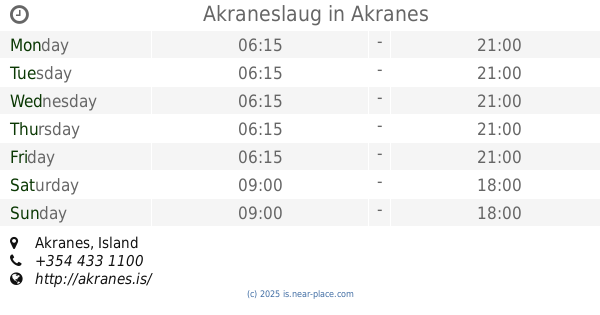
Akranes, Island
contacts phone
:
+354
Latitude:
64.317896
, Longitude:
-22.0668554
larger map & directions
read more
nearest Point of interest
365 m
Model
Stekkjarholt 6, Akranes
Point of interest
read more
384 m
Akraneslaug
Akranes
Point of interest
read more
427 m
Sement factory
Faxabraut 20, Akranes
Point of interest
read more
431 m
Landmælingar Íslands
Stillholt 16-18, Akranes
Point of interest
read more
507 m
Akranes
4, Einigrund, Akranes
Point of interest
read more
516 m
Héraðsskjalasafn Akraness
Akranes
Point of interest
read more
556 m
Brautin Car Rental
Dalbraut, Akranes
Point of interest
read more
631 m
VS Tölvuþjónusta
Akranes
Point of interest
read more
633 m
Ritari ehf
Esjubraut 49, Akranesi
Point of interest
read more
635 m
StayWest
Esjubraut 49, Akranes
Point of interest
read more
734 m
Endurskoðunarstofan Álit
Akranes
Point of interest
read more
756 m
Akranes Bryggja
Akranes
Point of interest
read more
785 m
Úr og Skart
Suðurgata, Akranes
Point of interest
read more
796 m
Topp Spjall
Smiðjuvellir, Akranes
Point of interest
read more
810 m
Tölvuverkstæði DJ Danna
Smiðjuvellir 14, Smiðjuvellir, Akranes
Point of interest
read more
811 m
Skaga Rásin
Smiðjuvellir 14, Akranes
Point of interest
read more
837 m
Íþróttahúsið við Vesturgötu
Vesturgata 130, Akranes
Point of interest
read more
848 m
Textaland
Suðurgata 57, Akranes
Point of interest
read more
878 m
Reiðhjólaverslun og verkstæði Axels
Merkigerði 2, Akranes
Point of interest
read more
894 m
Norðursýn
Faxabraut 3, Akranes
Point of interest
read more
895 m
Police
Þjóðbraut, Akranes
Point of interest
read more
899 m
Akrasel
Ketilsflöt 2, Akranes
Point of interest
read more
938 m
Bjarnalaug
Laugarbraut 6, Akranes
Point of interest
read more
966 m
Íþróttahús Akraness
Akranes
Point of interest
read more
1.128 km
Smiðjuloftið
Smiðjuvellir 17, Akranes
Point of interest
read more
📑
all categories
Accounting
Administrative area level 1
Administrative area level 2
Airport
Amusement park
Aquarium
Art gallery
Atm
Bakery
Bank
Bar
Beauty salon
Bicycle store
Book store
Bowling alley
Bus station
Cafe
Campground
Car dealer
Car rental
Car repair
Car wash
Casino
Cemetery
Church
City hall
Clothing store
Convenience store
Country
Courthouse
Dentist
Department store
Doctor
Electrician
Electronics store
Embassy
Establishment
Finance
Fire station
Florist
Food
Funeral home
Furniture store
Gas station
General contractor
Grocery or supermarket
Gym
Hair care
Hardware store
Health
Hindu Temple
Home goods store
Hospital
Insurance agency
Jewelry store
Laundry
Lawyer
Library
Liquor store
Local government office
Locality
Locksmith
Lodging
Meal delivery
Meal takeaway
Mosque
Movie theater
Moving company
Museum
Natural feature
Neighborhood
Night club
Painter
Park
Parking
Pet store
Pharmacy
Physiotherapist
Place of worship
Plumber
Point of interest
Police
Post office
Premise
Real estate agency
Restaurant
Route
Rv park, camping
School
Shoe store
Shopping mall
Spa
Stadium
Storage
Store
Subpremise
Supermarket
Synagogue
Taxi stand
Transit station
Travel agency
University
Veterinary care
Zoo
sublocality level 1
↑